31 August 2020 Colorado Basin Drought Update
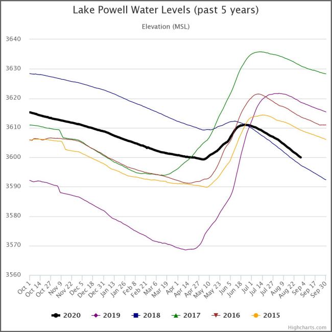
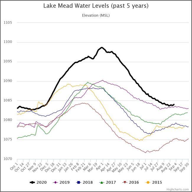
The water year begins on October 1 and ends on September 30. That can cause some confusion when comparing data because some declare the water year as the year it begins, others as the year it ends.The Lake Powell and Lake Mead graphs illustrate the lake elevations for the current water year plus the preceding five years. Lake Powell collects the snowmelt of the Upper Colorado Basin, which brings significant elevation changes to Lake Powell while allowing Lake Mead to maintain a more consistent elevation (not apparent in the different scale graphs above: Lake Mead graph resized to the same scale as Powell).
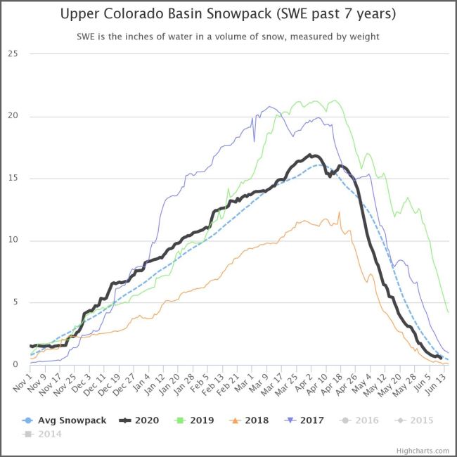
The snowpack is gone - 64% of average; 64% of nothing is still nothing; the snowpack graph will not be updated after this update (16 July) until the snow flies this fall. More bad news: rivers feeding Lake Powell are 57.7% of average. Precipitation 1s 79% of average.
Lake Powell is 100 feet (30.5 m) below full pool at 48% of capacity, down 18.7 feet (5.7 m) from this date last year. The graph vivdly illustrates the situation: after traling only 2018 for the year, it now leads only 2018, after this year's snowmelt runoff of just inder 12 feet (3.7 m} - the lowest in years. Lake Powell's open marinas are Wahweap, the main marina, Hall's Crossing, Bullfrog, Castle Rock Cut-Off, and Antelope Point; Dominquez Butte Cut-off is below minimum elevation. Hite Marina is 45 feet (13.7 meters) below minimum elevation, remains closed. Hite Marina has been open once in the last decade (2012). I was there at last year's high elevation (31 July 2019) - not a boat in sight (photo). I will not be there this year (2020).
Lake Mead is at a 7-year high elevation for this date at 40% of capacity, 135.6 feet (41.3 meters) below full pool. The lake is about level with last year (+8 in), but still 41 feet (12.5 m) below drought level. Boulder Harbor (replacing closed Lake Mead Marina), Kingman Wash, South Cove, and Temple Bar marinas/boat launches are open. Government Wash Launch, Las Vegas Bay Marina, Pearce Ferry Launch, and Overton Beach Marina are closed. An all-time low record was set on July 1, 2016 - down 148 feet - 45 meters.
The US Bureau of Reclamation - the agency charged with managing water in the West Select a tile at the top of the page to view the graphs of the lakes from Water Data, constructed with data provided by the USBR.
Select Minute 319 from the menu for information on the historic agreement between the US and Mexico on the storage and release of Mexico's water allotment that allowed the Colorado River to reach the ocean (Gulf of California to the Pacific Ocean) in 2014 for the first time in 16 years.