History of the Bridges and Distances Between the Bridges
Getting exact details is difficult at best, but here is what we have been able to come up with to document the data that we use that comes from other sources. We use river miles to establish our distances, which is far less than highway miles - substantially fewer miles is most cases; but definately longer than air miles. We do not know which type of distances our sources use - river miles or highway miles - accordingly we cannot prove nor disprove the mileages, but we come close with river miles. Our sources include the USBR, USGS, BLM, and Benchmark maps - listed at the bottom.
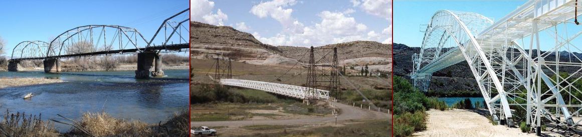
We have no data prior to 1900, there may have been only ferries, no bridges, but we have been able to document the following information. The first bridge we know about is the bridge at Fruita, Colorado, built in 1907, which documents our eastern point - the bridge on the left above. It is still standing today with new piers, and the floor has been stabilized; there is no access to it - the old road leading to it is blocked. We know of no other bridges in that time frame southwest of Fruita for the 1,080 river miles to the US-Mexico border. In this article we do not consider railroad bridges, with the exception of the Red Rock railroad bridge that temporarily carried US66 (and the railroad) between 1914 and 1916.
The US66 bridge at Topoc, Arizona, to Needles, California, the bridge on the right in the banner, was built in 1916, establishing our western point. It is 846 river miles from the Fruita bridge to the US66 bridge, that's a long-distance barrier between the northwestern and southwestern US. A bridge was completed in the same year (1916) at Dewey, Utah, the center picture in the banner, a distance of 783 river miles from the US66 bridge. The Dewey Bridge was the longest suspension bridge in Utah until it was destroyed by fire in 2008. A bridge was built across the Colorado at Moab, Utah, in 1912, that comes in at 739 river miles from the US66 bridge. At this point it shoud be noted that these were local bridges, there were no cross-desert roads connecting them - river traffic was the way to move distances up and down the Colorado. The only way to cross the Colorado was by ferry - frought with accidents in the swift currents. The Old Spanish Trail (map) offered a treacherous mountainous and desert route from Fruita to Needles (and on to Los Angeles), and there were other wagon trials throughout the west. The US highway system didn't exist until the Federal Aid Highway Act of 1925 started planning the national highway system. So, in the early 1900s, bridges were used for local traffic, distances between them were irrelevant.
Now, the bridges that were built to break up these great distances and allow cross-Colorado River travel as the US highway system was being built - the bridges we use today. US89 on the Grand Canyon Bridge over Marble Canyon opened for traffic in 1929, renamed Navajo Bridge in 1934. It was superceded by the new Navajo Bridge in 1995, with the historic bridge as a walkway over Marble Canyon. Hoover Dam was finished in 1936 with US93 crossing on top of the dam. The Hoover Dam Bypass was completed in 2010, moving the highway off the dam. The Glen Canyon Dam bridge was finished in 1959 in preparation for building the dam. US89 was rerouted over the bridge, with the road over Navajo Bridge becoming Alternate US89 (US89A). The Bridge at Hite Crossing was built in 1966, replacing Chaffin's ferry at Hite Crossing, which would be unundated by Lake Powell.
The current river mileages between the bridges follow. It is 63 river miles from the Co340 bridge that replaced the old Fruita bridge to the Dewey bridge; it is 31 river miles from the Dewey bridge to the US191 bridge at Moab, Utah. It is 138 river miles from the bridge at Moab to the Bridge at Hite Crossing that crosses the Colorado and Lake Powell (when at normal levels). It is 143 river miles from Hite Crossing to the Glen Canyon Dam Bridge, and Navajo Bridge is 21 miles downstream from Glen Canyon Dam. There is .3 mile between Hoover Dam and Hoover Dam Bypass, 342 miles downstream from Navajo Bridge. It is 69 miles downstream from Hoover Dam to the Laughlin bridge, and 39 river miles to the I-40 bridge that replaced the US66 Topoc bridge in 1966. That is a total of 846 river miles between the Fruita bridge and the I-40 bridge at Topoc, Arizona, and Needles, California. The US66 bridge is still in service, now used to support pipelines across the Colorado.
The USBR documents the lower Colorado River from the Gulf of California to Lee's Ferry, but not the Upper Colorado, so we use a USGS map, Benchmark Maps, and the BLM for the Upper Colorado from the Paria to Fruita.
[Note that the NPS sites are not always reliable - they work sometimes, sometimes not.]
1906-7 Fruita bridge: Historical data at nps.gov (sometimes broken), Preservation info at ColoradoPreservation.org.
1912 bridge at Moab: History at MoabHappenings.com (13th paragraph).
1916 Dewey bridge: historical info at Wikipedia in their article on Utah State Route 128.
1916 US66 Old Trails Bridge
at Topoc/Needles: history at NPS, Route 66 history at AzRt66.
1890 Red Rock railroad bridge: Mohave County Highways, the bridge that carried Route 66 between 1947 and 1970 when the I-40 bridge opened.
The river miles for the US66, Hoover Dam, and Navajo bridges come from the USBR rvmiles document (may not open in Chrome).
The river miles between Navajo and Glen Canyon Dam bridges come from a USGS map, supplemented by the USBR document.
The river miles in Utah are printed in the Utah Road & Recreation Atlas,
a copy is no longer available online.
The 42 river miles in Horsethief, Ruby, and Westwater canyons comes from the BLM - pouring through their sites has not yet revealed the document that provided that data.