Geology of Dead Horse Point
GEOLOGY OF THE MOAB REGION
(Moab Region on the menu) is Dr. Foos' study of Arches, Dead Horse Point, and Canyonlands (more below).
Dead Horse Point State Park and Vicinity [Geologic Road Logs . . ] comes from the Utah Geological Survey (includes the graphic on the right, select it to open a larger version).
Both are pdf documents, may take a second or so to load.
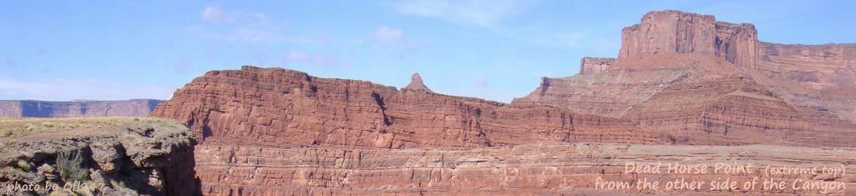
The text below is from the aforementioned NPS document Geology of the Moab Region (pdf) by Dr. Annabelle Foos, Geology Department, University of Akron. “Dead Horse Point is a rock promontory surrounded by steep cliffs. The topography of this area, with broad flat mesas and steep sided cliffs is typical of flat lying strata that weathers in an arid environment. Under arid conditions, soils are either very poorly developed or lacking, and rock fall is the major mass wasting process. Resistant sandstones and limestones form vertical cliffs and the less resistant shales form gentle slopes. Erosion of valley walls is by vertical scarp retreat. Shales are eroded by sheet wash on barren rock after the infrequent but intense rainfalls. Undercutting of the shales, leaves the resistant beds (sandstones and limestones) unsupported. Eventually large blocks break free leaving behind a vertical cliff. The elevation of Dead Horse Point is 6,000 feet, with a 2,000 foot drop, to the Colorado River, in a distance of approximately one mile. The Cutler Group is exposed at the base of the stratigraphic section, starting with a limestone bed of the Elephant Canyon Formation at the level of the Colorado River. The White Rock Sandstone (Cutler Group) forms the first major cliff below the broad flat bench that occurs near the top of the gooseneck. The next unit is the brown, slope forming siltstones and sandstones of the Moenkopi Formation. A thin, bench forming, white sandstone marks the contact between the Chinle and the Moenkopi Formations. The purple to red clayey sandstones and siltstones of the Chinle Formation form slopes up to the base of the Wingate Sandstone. The vertical cliffs of red, Wingate Sandstone are capped by the Kayenta Formation which we are standing on. In the distance are white, rounded hills of Navajo Sandstone. The gooseneck is an example of an incised meander. The Colorado River established it's coarse on a broad flat plain where it developed broad meander loops. A sudden lowering of the river's base level either due to uplift of the Colorado Plateau or stream capture of the Colorado caused it to start rapidly down cutting, leaving the meanders incised within canyon walls.” [quoted with permission]