Dead Horse Point State Park
From Discover Moab: 32 miles (51.5 km) from Moab, Dead Horse Point State Park is one of Utah's most spectacular state parks.
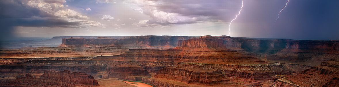
The view from Dead Horse Point is one of the most photographed scenic vistas in the world.
Towering 2,000 feet above the Colorado River, the overlook provides a breathtaking panorama of Canyonlands' sculpted pinnacles and buttes.
Millions of years of geologic activity created the spectacular views from Dead Horse Point State Park.
Deposition of sediments by ancient oceans, freshwater lakes, streams and wind blown sand dunes created these rock layers . .
Dead Horse Point State Park sits on a plateau at 5,900 feet (1,798 m) surrounded by steep cliffs. U313 to the park is 28 miles (45 km) south of I-70, or 7 miles (11 km) north of Moab on US191. It is 23 miles (37 km) on U313 from US191 to the park, where U313 crosses a narrow neck that is 90 ft (27 m) wide to reach the Point. The park has several overlooks along the edge of the cliffs, a visitor center, a 21-site campground and a group campsite, a picnic area, and several hiking trails of various lengths. Cliffs without guard rails and lightning strikes require vigilance, particularly if children are present. The park is isolated - food, drink, gasoline, and medical care are 30 miles (48 km) away in Moab. The road straight ahead, as U313 turns east toward the park, goes to to the Canyonlands Island in the Sky Visitors Center.
There are miles of developed hiking trails in the park, including a paved trail which provides easy access to some of the most scenic views. Mountain Bikers will love the new Intrepid Trail System at Dead Horse Point.
With slickrock sections, looping singletrack, sandy washes, and incredible scenery, the Intrepid Trail System provides a great taste of what Moab mountain biking is all about.
This is the perfect ride for families and offers spectacular views of the Colorado and Canyonlands.
[Discover Moab]
The Photo Gallery has twelve varied views from and of Dead Horse Point including the Thelma and Louise jump point, and two panoramic views.
View Photos is an auto-show of the photos.
DHP Geology contains excerpts from NPS and the Utah Geological Association with links to the complete articles.
The Legend of DHP tells how the Point may have gotten its name.
Park Maps shows biking and hiking trails, and identifies ten scenic overlooks (there is another at the visitors center and there are many overlooks along the hiking trails).
Area Map ls a highway map of the area.