The Grand Staircase
Note: This article is about the huge geologic formation known as the Grand Staircase (graphic above); the Grand Staircase-Escalante National Monument in Utah is a different topic (on the National Parks menu). It seems to me that no one is interested in the Grand Staircase anymore, just in the National Monument, but we found sufficient material to put this article together.
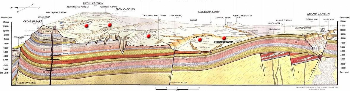
The huge Grand Staircase geologic formation extends from the bottom of the Grand Canyon in Arizona to the top riser of Bryce Canyon on the west and Boulder Mountain and the Aquaruis Plateau on the east, both in Utah. The land rises in broad, tilted terraces which form the Grand Staircase. From the south the terraces step up in great technicolor cliffs: Chocolate, Vermilion, White, Gray, and Pink Cliffs. Together these escarpments expose two billion to 600 million years of the earth's history in a dramatic geologic library. The deep, brilliant red Vermilion Cliffs contain many fossils of fish and early dinosaurs from the Triassic Period. Much of the text and images in this article come from the Wikipedia article.
The layers that form the Staircase have undergone 5,000 to 10,000 feet (1,500 to 3,000 m) of uplift starting with the Laramide orogeny, a mountain building period that formed the geology from the Pacific coastal ranges of North America to the Rocky Mountains (satellite view of the geology}. Streams eroding their paths through the uplift created the great canyons of the Colorado Plateau including Grand Canyon, Little Colorado River Gorge, Glen Canyon, Marble Canyon, Zion Canyon, and the canyons of Green River. The nearly 40 identified rock layers of Grand Canyon form one of the most studied geologic columns in the world. Stratigraphy identifies 18 of these layers, placing them in three historical groups.
The NPS article on geology that included keys to the red dots the graphic above no longer exists, but the Utah Geo[logical] Survey paper (2-page PDF, on our server) and the Wikipedia article provide a rudimentary overview. The BLM document on the geology of the Grand Staircase- Escalante National Monument (GSENM Geology, a 43-page PDF that may take a few seconds to load) provides in-depth information that also applies here.
The Relief Map is a no-frills topographic map scanned from the Utah Geological Survey - the only map I could find. It's all about the Monument now, even maps labelled Grand Staircase
are of the Monument.
The Staircase is being blurred by the controvesrial land-grab by President Clinton.
More controversy has come from President Trump reducing the size of the monumnent, creating three national monuments in the process that includes a Grand Staircase National Monument (how is that for confusion? wonder if it will have a new name?).
As more information becomes available and as that monument is formed, this page will be updated.