Lake Mead National Recreation Area
The Lake Mead National Recreation Area (NRA) spreads across 1.5 million acres (2,337.2 mi², 6,053.3 km²) of mountains, canyons, valleys, and two vast lakes. The area surrounding Lake Mead was established as the Boulder Dam Recreation Area in 1936. In 1964, the area was expanded to include Lake Mohave and its surrounding area and became the first National Recreation Area to be designated by the U.S. Congress. The Lake Mead NRA follows the Colorado River corridor from the western boundary of Grand Canyon National Park to just north of Laughlin, Nevada and Bullhead City, Arizona. Three of the four desert ecosystems found in the United States - the Mojave Desert, the Great Basin Desert, and the Sonoran Desert - meet in Lake Mead NRA. There are nine officially designated wilderness areas under the National Wilderness Preservation System lying within Lake Mead NRA.
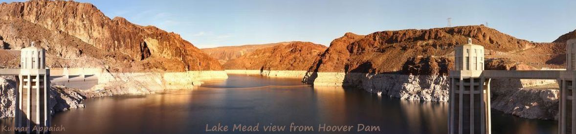
Lake Mead is the largest reservoir in the United States. At maximum capacity, Lake Mead is 112 miles (180 km) long and contains 26.12 million acre feet (32.22 km3) of water. Formed by the Hoover Dam (constructed as Boulder dam, finished in 1936, renamed in 1947), the reservoir serves water to the states of Arizona, California, and Nevada, serving nearly 20 million people and large areas of farmland. Lake Mead has been drastically affected by the drought with the closing of some marinas and boat launches. An all-time low was set on July 1, 2016, with the lake down 148 ft (45 meters).
Lake Mohave is a small reservoir created by Parker Dam at the south end of Lake Mead NRA. It is long and narrow, essentially stretching from Hoover Dam to Parker Dam, with a maximum width of 4 miles (6.4 km), an average depth of 75 ft (23 m), and at an elevation of 647 feet (197 m). Lake Mohave contains 199,500 acre feet (246.1 million cubic meters). There are three resorts on Lake Mohave: Katherine Landing and Willow Beach in Arizona and Cottonwood Cove in Nevada. Lake Mohave is relatively stable with all marinas and boat launches open for business.
The Photo Gallery includes photos of Lake Mead behind Boulder City, the Desert Princess paddlewheeler between the walls of Black Canyon with drought-exposed bath tub rings, a diver looking at the propeller of the B-29 that crashed into Lake Mead, marinas, Hoover Dam, and other photos of Lake Mead and Lake Mohave in Lake Mead NRA.
View Photos is an auto-show of the photos in the photo gallery.
Lake Mead NRA Map is a large, resizable pdf map that may take time to load, according to the internet connection.
Area Road Map is a wide area highway map of roads surrounding Lake Mead NRA and the Grand Canyon.
B-29 Crash at Wikipedia tells the story of the crash of the B-29 bomber into Lake Mead in 1948.
Photos of Lake Mead in drought may be found in our Colorado Basin Drought article.