Moki Dugway on Scenic Byway 261 & Muley Point
Mexican Hat, a census designated place, population 88 (2000), gets its name from Mexican Hat Rock at the edge of town. A photo of the rock is in the gallery Moki Dugway is in scenic southeastern Utah on Utah state highway 261 on the Trail of the Ancients, 24 miles northeast of the Utah and Arizona border on US163, and 12.5 miles north of Mexican Hat, Utah. Moki Dugway drops 1,200' (365+ m) off the edge of Cedar Mesa Escarpment on graded 11% switchbacks into the Valley of the Gods. If not recently graded, washboard sections of the road may make it easier to descend the switchbacks rather than climbing them. It was so rough on my last trip that I would have turned around, if I could have, and come down it from the north a day or two later in the trip.
The term moki (also mokee) is derived from the Spanish word, moqui, a general term used by explorers in this region to describe the Pueblo Indians they encountered as well as the vanished Ancestral Puebloan culture.
The Dictionary of the American West defines a dugway as, A road or trail going through a high land form which is dug out of or excavated into the land form to provide a path for transport.
It is a means of traversing a steep hillside without sliding down the slope.
The United States Geological Survey, Federal source for Science about the Earth, its natural and living resources, natural hazards, and the environment
From the USGS: Moki Dugway was built in 1958 for trucks hauling uranium ore.
The Moki Dugway is a gravel road, part of Highway 26 (sic), about 24 miles south of Natural Bridges National Monument.
The ancient inhabitants of this region had no such "highway" for travelling up and down the mesa.
Carved hand- and foot-holds and worn step-like paths of ancient American Indians can be found leading up cliffs and steep escarptments (sic) to food storage areas, dwellings, springs, or up steep escarpments . .
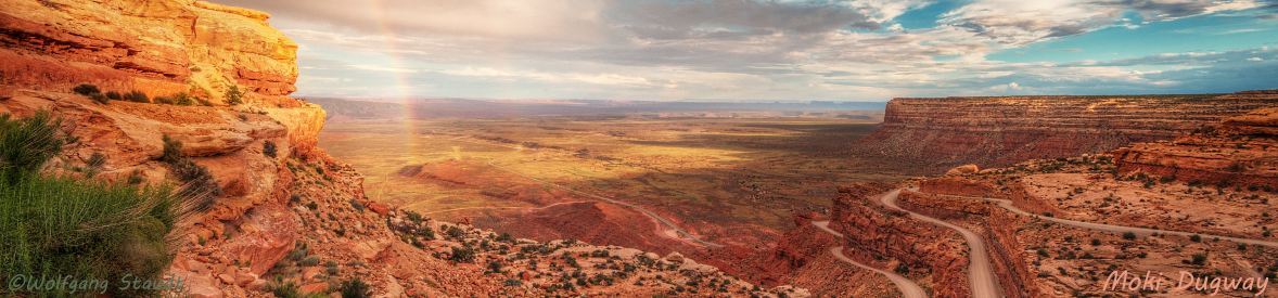
like the Cedar Mesa escarpment in the right background of the photo above.
Outstanding scenic panoramic views are visible from Muley Point on the edge of the Cedar Mesa escarpment, a little beyond the point visible in the background, reached by a dirt road off U261 just north of Moki Dugway. This back road to Mulely Point is faintly visible above the top of Moki Dugway on the U261/US163 map. Many people stop at the first overlook on the edge of the escarpment, which many call Muley Point, the road west to Muley Point, which is on the edge of the point, is significantly smaller and rougher. From Muley Point, Monumnent Valley is on the horizon behind Raplee Ridge, Goosenecks State Park is not far away, and the goosenecks of the San Juan River west of the park are immediately below the point.
Nearby are Natural Bridges National Monument, Ancestral Pueobloan ruins throughout Cedar Mesa, Glen Canyon National Recreation Area, Comb Ridge moncline, the Cockscomb monocline, Waterpocket Fold monocline (Capitol Reef National Park), scenic vistas, scenic byways, canyons and extremely narrow slot canyons, geologic formations, and primitive and wilderness areas.
View Photos is an auto-show of Moki Dugway photos including the U261 approach to the switchbacks, the Valley of the Gods from a switchback pullout, different views of the switchbacks, photos from Muley Point, and Mexican Hat Rock in front of Raplee Ridge. Raplee Ridge occupies the lower right corner of the US163/U261 map south and east of US163, the Goosenecks State Park map comes from our article on the park.