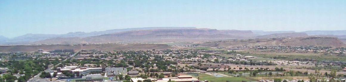
St George, Utah - History & More Information
Intermountain West: The Intermountain West, or Intermountain Region, is a geographic and geological region of the western United States between the Rocky Mountains on the east and the Cascade Range and Sierra Nevada on the west.
Washington County: County in the southwestern corner of Utah containing many early settlements, and 28 ghost towns.
The earliest known residents of the area were the Virgin River Ancestral Puebloans (Anasazi) from 200 BC to 1200 AD (dates approximate) - evidence of their existance is found in rock art and ruins. The Paiute Tribe arrived sometime between 1100 and 1200 AD, and remains in the area today. Tonaquint, named after the small Native American tribe in the area, was settled in 1855 on the banks of the Santa Clara at its confluence with the River Virgin. It was here in 1861 that Brigham Young offered his prophetic vision of the Rio Virgin Valley: "There will yet be built between those volcanic ridges a city with spires, towers, and steeples, with homes containing many inhabitants," which pretty much describes St George today. Tonaquint was destroyed by flood in 1862. Its location is inside St George City near the I-15/Dixie Drive interchange, with a city park, cemetery, hi-tech business park, and other nearby entities bearing the Tonaquint name. The area continues to suffer devastating floods, most recently in a 500-year flood in 2005, followed by a 100-year flood in 2010 where much damage was averted (potentially $135 million) as a result of measures taken following the 2005 flood.
Utah's Dixie: Early (mid-1800s) settlers of Washington County, many of whom had previoulsy lived in Alabama and Georgia, called the area Utah's Dixie because of its comparable temperate climate, albeit much drier than the southeastern Dixie.
In October, 1861, LDS Prophet Brigham Young, fearful that the civil war would negate the flow of cotton to the west, selected 309 families to settle in the Rio Virgin Valley to grow cotton, silk, and grapes. It is they who named the area Dixie, or Utah's Dixie.
The extreme heat, regular flooding by Rio Virgin, and alkali and clay soils made the task more than difficult, but cotton was produced somewhat successfully for 50 years (see photo: Washington Cotton Mill in the gallery).
Dixie State University: On September 19, 1911, St. George Stake Academy was established by the Church of Jesus Christ of Latter Day Saints (LDS).
In 1913 it became Dixie Academy, reflecting the area's common name as described above.
In 1916 it became Dixie Normal College, and Dixie Junior College in 1923.
The LDS Church discontinued its support in 1933, and it became part of the Utah System of Higher Education in 1935.
In 1970 the Junior
was dropped although its role remained unchanged.
In 2000, a proposal to offer baccalaureate degrees was approved, and the college was renamed Dixie State College of Utah.
With the increased educational needs of the population growth of Washington County (13,669 in 1970 to 144,809 in 2012) and student population (5,700 in 2006 to 9,000 in 2011), it became Dixie State University on February 16, 2013.
Nearby attractions include Snow Canyon State Park at the edge of town, Zion, Bryce Canyon, and Grand Canyon National Parks, Cedar Breaks National Monument, Red Canyon, scenic vistas, and interesting geology. Pine Valley Mountain, just north of St George, formed from the largest laccolith in the United States, may be the largest laccolith in the world. The entire Colorado Plateau is an amazing place to explore with historical cultural sites - rock art and ruins, and fascinating geology of valleys, mountains, canyons, monoclines, reefs, extremely narrow slot canyons, and much more than we can list here.
A dark page in history comes from nuclear fallout during the Atomic Energy Commission's above ground testing at the Nevada Test Site.
On May 19, 1953, the United States government detonated the 32-kiloton atomic bomb (code name Harry
) at the Nevada Test Site.
Later the bomb became known as Dirty Harry
because of the tremendous amount of off-site fallout generated by the bomb.
Winds carried fallout 135 miles (217 km) to St George, where residents reported an oddly metallic sort of taste in the air.
Winds regularly carried fallout through St George from above-ground testing at Yucca Flats beginning in 1951, including an underground test which escaped into the air in 1970 - the last known airborne fallout.
Marked increases in cancers such as leukemia, lymphoma, thyroid cancer, breast cancer, melanoma, bone cancer, brain tumors, and gastrointestinal tract cancers were reported from the mid-1950s through 1980 by the Journal of the American Medical Society.
Many residents watched the explosions from the mesas in St George, unaware of the danger that the fallout brought with it.