Trail of the Ancients Scenic Byway
The Trail of the Ancients (TotA) includes federal, state, and Navajo highways, county roads, and ancient roads in Utah, Colorado, Arizona, and New Mexico.
Sites along the TotA include Canyons of the Ancients, Mesa Verde, Hovenweep, Chaco Canyon, Canyon de Chelly, Hawkins, Yucca House, Mule Canyon, Aztec Ruins, Butler Wash, and many other cultural sites too numerous to list here.
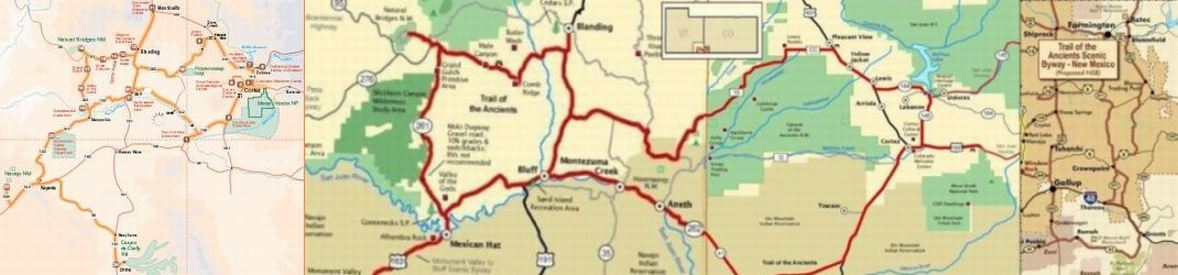
The banner includes four maps of the TotA, cut, cropped, resized, and assembled to fit into the banner.
The area surrounding the TotA (the Four Corners
area) contains the greatest concentration of ancestral Puebloan cultural sites north of Mexico.
Trail of the Ancients is the only National Scenic Byway totally dedicated to archaeology and, unique to this byway, the traveler must get out of the car to truly experience everything the byway has to offer.
[Colorado Byways]
There are several definitions of the Trail of the Ancients.
The  FHWA defines the
 Trail of Ancients National Scenic Byway
in Utah and Colorado (center section of the banner, Utah and Colorado TotA maps).
The Navajo/New Mexico, from a site no longer available, shows the Trail of Ancients Scenic Byways in Utah and New Mexico with additional tracks in Colorado and Arizona (right side of the banner, Navajo TotA map).
The map of Trail of the Ancients Scenic Byway, NM
from Aztec, New Mexico, is a larger version of the New Mexico section of the Navajo map that surrounds (but does not show) the Chaco Culture National Historic Park, see the Prehistoric roads map for the detail inside the highways.
A Trail of the Ancients National Scenic Byway Map & Guide
brochure, no longer available, provides us with the TotA with Arizona map that includes Utah and Colorado, excludes New Mexico, and shows a different route to Canyon de Chelly in Arizona than does the Navajo map.
Prehistoric roads is a map of prehistoric and current roads with many Ancestral Puebloan sites in New Mexico with Chaco Canyon as their hub. Note that the highway numbers on the prehistoric roads map are also prehistoric - corrections may be in the Chaco Culture article.
The Wide area map from My Grand Canyon Park spans from Denver on the east to Las Vegas on the west, and Salt Lake City on the north to Juarez on the south. The map oriented on the Grand Canyon shows national parks and some archealogical sites.
The remaining menu entries are maps of some of the archaeological sites along the Trail of the Ancients. The Scenic Color Country Archaeology menu contains articles and photos of these and other sites along the TotA and Nine Mile Canyon, Santa Clara River Reserve, and Montezuma Castle that are in Scenic Color Country but not on the Trail of the Ancients.
Here are photos from along the Trail of Ancients for which we do not have articles: Zuni Pueblo, Hawkins Pueblo, and Yucca House (reconstruction).