White Rim Trail, Mineral Bottom Road,
Shafer Trail, and Long Canyon Road
One of four districts in Canyonlands National Park, Island in the Sky is a sandstone mesa 1,000+ ft (305+ m) above the surrounding area in the wedge created by the Green and Colorado Rivers.
It has three geologic levels - Island in the Sky, which is surrounded by the White Rim (hence the White Rim Trail around the rim), which is bounded by Stillwater Canyon (Green River) and Meander Canyon (Colorado River).
There are at least three Long Canyons in the area - this one near Dead Horse Point, Long Canyon on the Burr Trail east of Boulder, Utah, and Long Canyon into White Canyon near U95 between Fry Canyon Lodge and Hite, Utah.
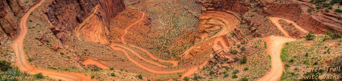
The White Rim Trail surrounding the Island in the Sky Mesa in Canyonlands National Park, Mineral Bottom Road, Shafer Trail, and Long Canyon Road are rugged back roads that provide awesome scenic views (and panic on the switchbacks?). It should be noted that all four of these roads are listed on dangerousroads.org and should be travelled only when they are completely dry. The White Rim Trail can only be reached by dropping down switchbacks on the Mineral Bottom Road on the west (photo in the gallery) or Shafer Trail on the east (banner photo). Both roads are identified on many maps and web sites as being on the White Rim Trail (the Shafer switchbacks banner photo is named “whiterimtrail” by its author). And Mineral Bottom Road and Shafer Trail have multiple names, adding to the confusion. These are rugged and dangerous roads on a desolate high desert plateau with no potable water, 1000' cliffs without guard rails, no cell access, and no nearby medical services - no services of any kind - the cost of towing a disabled vehicle from the White Rim Trail will probably exceed $1,000. It should also be noted that animals (bear, bobcat, etc.) live in this wilderness. All routes to the White Rim Trail begin off US191 north of Moab: U313 10 miles north of Moab, and U279 2 miles north of Moab. Also note that the Shafer Trail and Long Canyon Road are restricted to street-legal vehicles.
The White Rim Trail meanders for 100 rugged miles betweem Mineral Bottom Road and Shafer Trail, beside Green River, then across the White Rim around Island in the Sky Mesa, with scenic views, canyons, trails, and campgrounds along the Trail. DangerousRoads.org says the drive requires 2-3 days, other sources say it could be driven in 10-12 hours in excellent weather with limited traffic. The photos tell the story of the White Rim Trail.
There are three main routes to the White Rim Trail; two begin with Utah highway 313 (U313) and the third with Utah highway 279 (U279).
Utah highway 313, the Dead Horse Point Mesa Scenic Byway, west off US191, 10 miles north of Moab, is the usual beginning point.
The first route to the Trail begins with Mineral Bottom Road, which turns west off U313, 12.2 miles west of US191. Mineral Bottom Road goes across a mesa, drops down crazy switchbacks, and and meets the west end of the White Rim Trail near Green River, 12.9 miles west of U313.
The second route to the White Rim Trail from U313 begins with the Shafer Trail - 8 miles from Mineral Bottom Road, 5.6 miles beyond where U313 turns east toward Dead Horse Point State Park. At the U313 turn, the road continues straight ahead as the Island in the Sky Road (also known as Grand View Point Road) into Canyonlands National Park to the Shafer Trail. Shafer Trail turns west a short distance before (north of) the visitors center, descends the switchbacks pictured above, and meets the east end of the White Rim Trail 5.3 miles from Island in the Sky Road.
The third route via Utah highway 279, aka Potash Road, begins 2 miles north of Moab, just across the Colorado River Bridge, as U279 turns west off US191. It loses state road designation when the pavement ends at the Potash boat ramp and becomes Potash Road (the BLM map says it becomes Shafer Trail at this point), passes the Long Canyon Road turnoff, and continues as Shafer Trail. Shafer Trail passes below Dead Horse Point, and intersects the east end of the White Rim Trail 5.3 miles west of Island in the Sky Road. This road has several names which are dicussed below.
Now we can define these three interesting, sometimes dangerous, roads that lead to the White Rim Trail.
Mineral Bottom Road is the commonly used name and the name we use - it goes to Mineral Bottom at Green River. Its two official names are Horsethief Trail and BLM129. The BLM also calls it the Mineral Canyon road on some of its maps. Mineral Bottom Road turns west off U313 12.2 miles southwest of US191 (2.4 miles before U313 turns toward Dead Horse Point State Park), goes across the mesa, drops down the switchbacks, and meets the White Rim Trail near Green River, 12.9 miles west of U313. Maps disagree on where Mineral Bottom Road ends, some say at the Mineral Bottom boat ramp, others at the airstrip, and others say it continues on to the Denis Julien inscription of 1836 at the mouth of Hell Roaring Canyon (the map agrees with the latter; the map also shows a trail up Mineral Canyon to a defunct uranium mining site). This much we know: whatever the name of the road, it continues its scenic drive alongside Green River up Labrynth Canyon amid 500' (152+m) cliffs past the airstrip to Hell Roaring Canyon, turning a short distance up Hell Roaring Canyon (the map does not show this, but Google Earth does). The Mineral Bottom Road map we have does not show the junction with White Rim Trail, and stops just short of Hell Raising Canyon. The best map view of its junction with the White Rim Trail is the White Rim Trail map (actually it's the Canyonlands Island in the Sky map); this map shows Mineral Bottom Road ending at the boat ramp.
Shafer Trail - Potash Road - U279. The Shafer Trail (west end) begins at Island in the Sky Road 8 miles south of the U313-Mineral Bottom Road junction (just before, north of, the Visitors Center), drops down switchbacks into Shafer Basin, meets the White Rim Trail 5.3 miles from Island in the Sky Road, and continues east in Shafer Basin past Dead Horse Point to the intersection with a trail headed north up a canyon next to Dead Horse mesa, and this is where the controvesy begins. Some say that this is where Potash Road begins while Shafer Trail turns north up the canyon to its end - Benchmark Maps appears to agree. The BLM map says Shafer Trail continues until it meets U279 and makes no mention of Potash Road. Potash Road (and/or Shafer Trail) continues on toward Moab, paved at a Colorado River boat launch, and continues as U279/Potash Road in a deep Colorado River canyon (Meander Canyon) to US191, 2 miles north of Moab. The canyon contains petroglyphs and dinosaur tracks. The Shafer Trail is named Potash Road on various maps (including the Island in the Sky map from NPS). Other names for Shafer Trail and Potash Road are BLM 134 and 142.
Long Canyon Road splits left off U313 18+ miles from US191, just beyond an airstrip. It continues across Dead Horse Mesa, then descends steeply through narrow Pucker Pass and switchbacks into Long Canyon and ends at Potash Road, a distance of 7.4 miles. There is significant scenery along the way with a huge fallen boulder that forms an underpass. It is impassable during/after heavy rain (perhaps even light rain?).
An isolated, rugged, ≅120 mile scenic loop begins on Mineral Bottom Road at U313, down switchbacks to the White Rim Trail, along Green River and the White Rim around Island Mesa on White Rim Trail to Shafer Trail, west up the switchbacks to Island in the Sky Road, and back to Mineral Bottom Road at U313.
Or turn east on the Shafer trail and continue through scenic Shafer Basin and through the Colorado River canyon on Shafer Trail/Potash Road/U279 to Moab.
Note this road is AWD - the photos will confirm some really rough spots, although some have driven them in street cars.
These scenic loops also provide a +/- 150 mile two-day escape out of Mineral Bottom to Moab via U313 & US191 or via Shafer Trail when a flash flood washes out the Mineral Bottom switchbacks, as happened in August, 2010, closing the road for seven months.
Other scenic loops include U279-Long Canyon Road-U313-US191 back to U279, along with many other combinations of these roads.
Select View Photos for a menu of auto-shows of the photos - variably-sized photos in an auto-show are a little weird in that the controls may be inside, half-in, or outside the photo. Select Photo Gallery for an overview and to selective view the photos, and Trail & Road Maps for a menu of the maps.